| Deltarian Geography | |||||||||||||||||||||||||||||||
|---|---|---|---|---|---|---|---|---|---|---|---|---|---|---|---|---|---|---|---|---|---|---|---|---|---|---|---|---|---|---|---|
| |||||||||||||||||||||||||||||||

Deltaria is a large nation located in the south portion of Majatra, in the deepest point of the Majatra basin at 55˚S,66˚W. It is the sixth largest country in the world, with an area of 2,658,000 square kilometers, making it the largest nation in Majatra. Deltaria holds 76,352 kilometers of coastline, and an Exlusive Economic Zone of 953,876 square kilometers.
Deltaria is geologically stable, with few Erthquakes, as it is at the center of a tectonic plate. Many forces shapping Majatra happened in its early history, when the Terran Supercontinent split appart, and thus only minor earthquakes are seen in Deltaria.
In the central part of Deltaria is the Darali Basin, a large depression in the area which holds a large area of foliage and wildlife, as well as the Suislaw river at its northern point, before the Akigan Plateau. The center of the basin holds a sudden outcrop in the flat expanse, called Mount Tyrrin, and it is here that most of the forest remain. At the Basin's nothern borders, the locations of the Susilaw River, as well as lake Majatra, are the source of much irrigation for the rest of the Basin, and thus most of Deltarias food and livestock are kept here.
At the north of Deltaria is the Ushlande Horn, of of which is the largest coral reef on Terra, the Great Deltarian Reef. The Horn is a semi-tropical area, and thus many gems and other riches are found their, as well as fertile soil.
Deltaria also holds two main plateaus: the Akigan Plateau in the north, and the Jodian Plateau in the south-east. Majatra also holds the
The Deltarian Highland are an area along the coast of central Deltaria, which holds the most diverse wildlife and fuana, as well as Deltaria's tallest mountain, Mount Parnum.
To the east of the Highlands lies the Dissuwan Coastal Plain, which takes up must of Dissuwa and is one of the main agricultural sectors of Deltaria. It also is one of the main population centers, the others being the Ushlande Horn, Alazinder Corridor (the low area between the Highlands and Jodian Plateau), the Great Cannyon Gorge, and the borders of the Darali Basin.
Geology
Deltaria is relatively geologically stable, with only minor earthquakes. The weather has eroded at many of the mountaains, and thus the country is very flat, even the hoigh elevations are plateaus, with the only real mountains and hills being in the Deltarian Highlands and Mount Tyrrin. There is no Volcanism in Deltaria, and other disasters such as tornnadoes or hurricanes are rare to nonexisitent. There are very fertile plains in the central, far eastern, and northen parts of Deltaria, with two main rivers running through the country. No place in Deltaria has permanent glaciers, but the highlands rarely hold snow.
There are also mineral deposists in Deltaria, consisting of iron, nickel, buaxite, zinc, and boron. There are also gold, copper, tin, tungsten, silver, and uranium deposits in Deltaria, as well as large quantities of crude oil in the plateaus.
These have been largely untapped until recently, but have yeilded much, making Deltaria one of the richest countries in Terra in terms of mineral wealth. The Oil has largely been used for consumption, but the government has made efforts to reduce their reliance on oil and begin using other energy sources like nuclear, solar, and wind so that they can export their oil, but so far this is only a work in progress. Diamonds have also been found in the far north of Ushlande and Dissuwa, and efforts have begun to harvest them.
Lakes and Rivers[]
Lake Majatra[]
Lake Majatra straddles the border between the Majatran nations of Cobura, Deltaria, Jelbe, Jakania and Zardugal. It is the largest, deepest and oldest lake in the Majatra, preserving a unique aquatic ecosystem with more than 200 endemic species that are of worldwide importance. However, human activity on the lake shores and in its catchment area is resulting in the ecosystem coming under stress. Lake Majatra holds a maximum depth of 288 m and a mean depth of 155 m. It covers an area of 1,358km²,

The shores of Lake Majatra
containing an estimated 245.4 km³ of water.The water at the surface of Lake Majatra moves predominantly in an anti-clockwise direction along the shore, as a result of wind forcing and earth rotation. In terms of vertical water exchange, convective mixing during winter cooling is the dominant process. However in an average winter only the top 150-200 meters of the lake are mixed, whereas the water below is stably stratified by salinity. The stability due to this salinity gradient allows complete convective mixing events only roughly once every 7 years. Both in terms of nutrient concentration, as well as biological parameters Lake Majatra qualifies as oligotrophic. Thanks to this oligotrophy and the filtered spring inflows, the water is exceptionally clear with transparencies to a depth of as much as 22 meters (66 feet).
Suislaw River[]
The Suislaw river is the second largest river in Deltaria, and flows north from Lake Majatra. One of the greater sites of Deltaria are the Suislaw Falls, where the river drops 60 meters just before entering the Darali Basin. It the meets up with Tributary Rivers before flowing along the border of the Darali Basin in Doron Akigo before again going through another waterfall and breaking off to go through the Akigan-Ushlande Corridor ( a low area between the Akigan Plateau and Northern Highlands), and finally flowing into Ushlande Bay.
Alazinder River[]
Rising in the northern hills of the Border Marches, 225 m above sea level, north-west of Nilaka City, the Alazinder heads north into Deltaria, past Chemnitz, Karvina, Dolinka, Jesenik, Stara Hut, Hradec Kralove, Sedlecany, Budejovice, Petrovice and Dublovice, and discharges into the South Sea at its outlet in Hodonin, 12 metres below sea level. The Alazinder has many tributaries, most importantly the Kama, the Oka, the Vetluga, and the Sura rivers. The Alazinder has a total length of about 470 kilometres and includes as many as 150 chanels. The Alazinder River drains most of Alazinder. Its many large reservoirs provide irrigation and in some areas, such as the Darali Basin, and hydroelectric power. The Hradec Kralove Canal, the Budejovice Canal, and the Hodonin Canal systems form navigable waterways connecting Hradec Kralove to the South Sea. The fertile river valley provides large quantities of wheat, and also has many mineral riches. A substantial petroleum industry centres on the Alazinder valley. Other minerals include natural gas, salt, and potash. The Alazinder Delta and the nearby South Sea offer superb fishing grounds. Hodonin, at the delta, is the centre of Deltaria's caviar industry.
Mountain Ranges and Plateaus[]
The Akigan Plateau[]
The Akigan Plateau is a large mesa in the north of Deltaria, dominating the most of Doron Akigo. It is very cold dry, with its only real source of water coming from the Willemetto River in the north-west, and the accasional aquifer. The rural region is sparsely populated, with any sightings of settelements inbetween the main cities are

A wooded area of the Akigan PLateau during winter.
rare. A very effective highway system which spans the whole of Deltaria goes over the Plateau, which allows people to travel from town to town without stopping at an uninhabeted area. The main comodity of the Akigan Plateau is Oil, which also provides most of the employment for Dorons and Akigans.
The plateau contains few trees, and is covered in small rocky outcrops and small hills. It is mainly covered in nearly frozen soil, but trees and shrubs are also present in the nearly subarctic semi-arid land. The elevation of the Plateau is about 372 m above sea level, and covers nearly the whole expanse of Doron Akigo and some of Ushlande at 310,324 square kilometers. The Plateau is a continental plateau, and does not have any mountains bordering it. To its north is the very flat and fertile Ushlande horn, which has a sub-tropical meditteranean-like climate. The climate is partially stopped at the highlands though, and the rest is cut at the Akigan Plateau, so the weather of Ushlande does not continue into the Darali Central Basin. The Plateau's sothern edge is shaped by the Suislaw River, which creates a Gorge and brings a halt to the Plateau.
The Jodian Plateau[]
The Jodian Plateau is another large plateau in the south east of Deltaria, crossing the lower parts of Alazinder and Dissuwa, most kown for the Great Cannyon Gorge, a large cannyon cutting throug the Jodian Plateau, formed by the Alazinder River. The Great Cannyon Gorge (or more commonly the Great Gorge) is a primary source of food, as there is enough space between the banks of the Alazinder RIver and the sides of the cannyon to put farms in place. As a result the gorge is a large source of food, along with the Dissuwan Costal Plain and Darali Basin.
The Plateau is similar to the Akigan Plateau, being semi-arid and almost subarctic, but unlike the Akigan Plateau the Jodian Plateau holds many mineral deposits. These are the driving force of the economy in southern Alazinder and Dissuwa, with the lead, copper, nickel, and tin found there used in Deltaria as well as shipped to other countries.


The map of Deltaria, with the Jodian Plateau in the south-east, the Akigan Plateau in the north-east, the Highlands along the coast, and the Darali Basin in between the plateaus, with mount Tyrrin in the center of the basin.
The Plateau is large, stretching accross two Provinces, but is not quite as large as the Akigan Plateau, with an area of 252,367 square kilometers. The plateau's easternmost section turns into the Tarar Ranges, a large mountain range with peaks almost as high as those of the northern Highlands. The Tarar's highest peak is Mount Karpaty, with a height of 1,489 m above sean level. As a whole the Plateau is about 345 m above sea level.
The Deltarian Highlands[]
The Deltarian Highlands are an area on the central coast of Deltaria, and extend from the borders of Dissuwa, all the way up along the coast to the borders of Ushlande. The Highlands are divided into two main sections, the Northern Highlands and the Central Highlands. The Northern Highlands have a higher elevation than the Central


a lower part of the Northern Highlands as viewed from the north of the Darali Basin.
Highlands, with the highest peak of the Northern Highlands, Mount Parnum, being the tallest mountain in Deltaria at 2,228 meters above sea level.
The Highlands are a key feature of Deltaria, as they block the semi-tropical climate of Ushlande and Northern Dissuwa from extending further south. The Highlands also hold the largest diversity of life in Deltaria, with many types of trees and animals.
The Highlands also provide mineral wealth for Deltaria, in the form of uranium, gold, copper, silver, tugsten, and other ores. The highlands are seen as temperate, as is the Darali Basin, and are key to a Deltaria seen today.
Grasslands and other Features[]
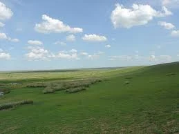
The Darali Basin[]
The Darali Basin is a temperate deppresion in central Deltaria, right imbetween the the Highlands and Plateaus. At its northern border is the Suislaw River, which Provides much irrigation for farmers in the Darali Basin, as does lake Majatra to the north-west. The Darali Basin is largely grassland, but in its center is a mountaneous

part of the Darali Basin
section covered in trees. This called Mount Tyrrin, and it is the source of much wood for Deltaria. The Basin is also a major poulation center, with many living here. The Basin is also connected to the Akigan-Ushlande Corridor and Alazinder Corridor, two other major population centers imbetween the Highlands and Plateaus.
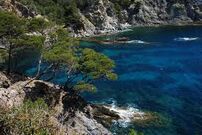
The Ushlande Horn[]
The Ushlande horn is a key area, another population center in the far north. It is semi-tropical, and also has diamonds and and other minerals, as well as fertile soil and trees. The Horn is very large, and is home to many port cities which import and export goods to other countries, as well as send out ships to patrol Ushlande Bay. The Horn is very flat as well, with almost no

A picture of the Ushlande Coast.
mountais and is practically at sea level. The Horn is famous for its small white cliffs, and also serves as a marble area. Another great atraction of the area is the Great Deltarian Reef, the largest reef in Terra, a marvelous area for tourists to come and see the wildlife, such as the South Seas Shark, an indigenous animal, and the stripped lionfish. These attractions spur a flourishing tourist industry in Ushlande, and fishermen are also allowed, but not in protected areas.
The Dissuwan Coastal Plain
The Dissuwan Coastal Plain is an area in north and central Dissuwa, that houses a large population and is also a large agricultural area. It is very flat, and at a low altitude, and also has incredible soil for planting. These all make the area an atttractive place to live in, and it is. Many people do inhabbit the area, and agriculture is the dominant industry, with most of the factories in Doron Akigo, Ushlande, and Alazinder. The area also host a thriving fishing industry on teh coast, at the edge of the plain.
The Alazinder and Akigan-Ushlande Corridors[]
Thhese two areas are located as low altitude areas nestled in between the the plateaus, either the Akigan Plateau or Jodian Plateau, and have large populations and resonable agricultural sectors, but much of the focus is on Industry. The areas are the beating hearts of Deltaria's production sector, and are also good places for high end jobs in Deltaria.
Climate[]
The climate of Deltaria is varied, with the areas on the coast, namely the Ushlande horn and Dissuwa, are semi-tropical areas that have abundant human and wild populations. Rainfall is high there, and there are hot summers and at worst cool winters. The only semi-arid areas of Deltaria are the two Plateaus, and have very low rainfall and hot summers and resonably warm winters as well. The Highlands and Darali Basin are both temperate areas, and have moderate rainfall and cool to cold winters and moderately warm summers.
Natural Disasters and Hazards in Deltaria are rare, with only small earthquakes being felt and tornados nonexistent. Hurricanes are extremely rare as well. Drought may affect the Plateaus however, and sometimes there are floods on the Dissuwan Coastal Plain.
Political Geography[]
After the overthrow of the Czars, Deltaria was broken up into a vast multitude of tiny administrative sections known as Counties, which generally consist of small towns, villages and hamlets, which usually have mayors presiding over them. These Counties in turn are grouped into larger administrative regions known as Districts, consisting of a larger town or small city and their surrounding settlements. These Districts are managed by a district governor and his cabinet. The heirarchy continues to the Territory, where the administrative governments of larger regions resides in the major cities. Finally, the nation is broken into five Provinces, Alazinder, Darali,Dissuwa, Doron Akigo, Ushalande, whose governments answer to the Head of State, Head of the Government and his cabinet.
Wildlife[]


A Deltarian Blue Octopus
Wildlife in Deltaria is much the same as the rest of Majatra. Flora makes up a vast assemblage of plant species estimated to over 20,000 vascular and 14,000 non-vascular plants, 250,000 species of fungi and over 3,000 lichens. Prominent features of the Deltarian flora are adaptations to aridity and fire which include scleromorphy and serotiny. These adaptations are common in species from the large and well-known families Proteaceae, Myrtaceae, and Fabaceae. The arrival of the Deltarians has led to the extinction of 61 plant species and endangering over 1000 more.
Deltarian fauna consists of a huge variety of animals; some 83% of mammals, 89% of reptiles, 90% of fish and insects and 93% of amphibians that inhabit the continent are endemic to Majatra. This high level of endemism can be attributed to the continent's long geographic isolation, tectonic stability, and the effects of an unusual pattern of climate change on the soil and flora over geological time. A unique feature of Deltaria's fauna is the relative scarcity of native placental mammals. Consequently the marsupials, a group of mammals that raise their young in a pouch, including the macropods and dasyuromorphs, occupy many of the ecological niches that elsewhere in the world are filled by placental mammals. Deltaria is home to two of the five known extant species of monotremes, and has numerous venomous species, which include the platypus, spiders, scorpions, octopus, jellyfish, molluscs, stonefish, and stingrays. Uniquely, Deltaria has more venomous than non-venomous species of snakes. Since the arrival of Deltarian colonists from Artania, 14 mammal, 20 bird and 4 frog species have been declared extinct.
Endangered Species[]
Majatran Eaglehawk
The Majatran Eaglehawk is a very large Majatran raptor and the third-largest of all the world's large eagles. It has long, fairly broad wings, fully feathered legs, and an unmistakable wedge-shaped tail. Both because of its size—it is one of the largest birds in the world—and because of the pointed tail, it can be identified at a glance as a even by the non-expert.
South Sea Sharks


A South Seas Shark
Sharks in Deltarian territorial waters are subject to organised hunts, in retaliation to infrequent shark attacks on Deltarian citizens. Although protected by most of the world, nurse sharks and Great Southern sharks aresometimes slaughtered by Deltarian sharkboats, but efforts have been made to bring down illegal hunting.
Amphibious Life
Dozens of amphibious fauna in Deltaria ; which are noted for their extreme intolerance to pollution, due to the absorbtion of nutrients through membrances on their skin, are becoming a subject of concern foor enviromentalists as factories become increacingly common in the country. Deltaria had begun to enforce moderate pollution to fight this endangering of species, but with varied levels of success. They have also tried to move on from fossil fuels to "cleaner" sources.
Introduced Species[]
Deltarian Bull Mastiff
The Deltarian Bull Mastiff, Deltaria's previous national animal, is among the largest breeds of mastiff, and is found in a heavier mastiff type, and a more moderately sized mountain type. Its sturdy bone structure and large, wide head makes it appear considerably more massive than other dogs of a similar height. It can reach heights over to 80cm at the withers, although the standard for the breed is typically in the 61 to 72 cm range. History records the largest of the breed weighs over 100kg, but dogs in modern times are more typically between 45 to 75kg. Its double coat is long and found in a wide variety of colors from solid black, to black and tan, various shades of gold (light to dark) and occasionally the dilute gray and brown are also possible.
Like other types of mastiffs, the larger variety can have greater size, a heavier head and more pronounced wrinkling, while the mountain type has a smoother rather than wrinkled brow with less jowling, giving them a drier mouth than other mastiff breeds. They are also hypoallergenic with a thick double coat that only moults once per year.
Artanian Brown Bear
Brown Bears in Deltaria, originally brought to the Deltarian colonies in Majatra for the purpose of bear-baiting ( a now extinct sport), are larger and more aggressive than their Artanian cousins due to selective breeding . Their heads are large and round with a concave facial profile. They generally have a head-and-body length of 2.4 to 3.3m and a shoulder height 150 to 200cm, although the abnormally large specimens exceed these measurements. Some exceptionally large Deltarian specimens are almost 4m in height while on their hind legs, and weigh about 880 kg. The largest Deltarian bear weighed over 1100kg, and was known by the name Veľký Zabijak.