| Country | Aloria |
| Regional capital | Llyn |
| Government | |
| Ruling party(s) |


Geography[]


Map of Krentori


The Krentori River


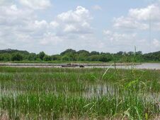
Waterways and wetlands forms most of the state's surface

The swampy inlands
The Krentori River and Bayou River form almost the whole state border with the rest of Aloria. Krentori is bordered to the north by the state of Sildar, to the east by the state of Gavonshire, to the south by Rutania and to the west by the Verranderlijke Ocean. The state has a total area of 191,400 km² , making it Aloria's second smallest state, after Ultran.
Krentori has 8 districts. Unlike other states, Krentori isn't heavily populated although it has soe larg cities, wich are located mostly at the Krentori River banks. The largest cities are Port Aloria (Aloria's fifth largest city) and the state capital Calliope.
The surface of the state may properly be divided into two parts, the inlands and the alluvial. The alluvial region includes low swamp lands, coastal marshlands and beaches. This area lies principally along the Verranderlijke Ocean coast and the Krentori River, which traverses the state from east to west for a distance of about 2,500 km and empties into the Verranderlijke Ocean. After the Krentori River passes Calliope, the river spreads out (and the Bayou River and Yellow River becomes distributaries of the Krentori) and drains into the ocean. The Krentori River flows along a ridge formed by its own deposits (known as a levee), from which the lands decline toward the low swamps beyond at an average fall of 3 m/km. The region has rich soil, partly made up of silt which had been regularly deposited by the floodwaters of the Krentori River.
The state of Krentori is entirely composed of lowlands, the highest point being only 246 m above sea level. The lowest point is sea level at the oceanic coast.
Ecology[]
Krentori is heavily forested, with over half of the state's area covered by wild trees; mostly pine, but also cottonwood, elm, hickory, oak, pecan, sweetgum and tupelo.
Due to seasonal flooding possible from December to June, the Krentori River created a fertile floodplain in what is called the Krentori River Delta, including tributaries. Early planters used slaves to build levees along the Krentori River to divert flooding. They built on top of the natural levees that formed from dirt deposited after the river
flooded. This gives the southernbank of the Krentori River a beautiful, various ecological system, wich also contributed to the excistence of the many inland waterways.
Krentori's west coast is composed of lush wetlands, home to the famous swamps, the so-called bayou. The City of Port Aloria occupies the Antarian River Delta a full 1,500 feet bloew sea level. In addition to keeping the water at bay, the system of dikes and dams surrounding Port Aloria provides Krentori's coastal wetlands with inexpensive hydroelectric power.
====Climate====
Krentori has a humid continental climate. Winters are moderate and a little on the short side, while summers are usually warm and of moderate length; spring and fall are distinct and refreshing periods of transition.
Krentori is often affected by cyclones and is very vulnerable to strikes by major hurricanes, particularly the lowlands around and in the Krentori Delta area. The unique geography of the region with the many bayous, marshes and inlets can make major hurricanes especially destructive. The area is also prone to frequent thunderstorms, especially in the summer. The entire state averages over 60 days of thunderstorms a year, more than any other state.
History[]
Economy[]


Soybean farm in eastern Krentori


Krentori's lumber industry

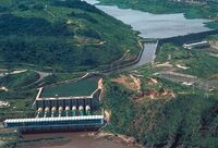
Hydroelectric power is Krentori's major source of energy
Krentori is an agricultural region. Krentori's agricultural outputs include poultry and eggs, cattle, plant nursery items, peanuts, cotton, grains such as corn and sorghum, vegetables, milk and soybeans. Krentori's industrial outputs include paper, lumber, and wood products.
Agriculture[]
The state's principal agricultural products include seafood (it is the biggest producer of crawfish in the region, supplying approximately 70%), corn, peanuts, soybeans, cattle, poultry and eggs, and dairy products.
Krentori's most valuable crops are corn and soybeans. Production of corn generates about 15% of the state's total agriculutural receipts.
Largely due to the domination of the plantation economy, focused on the production of agricultural cotton only, the state was slow to use its wealth to invest in infrastructure such as public schools, roads and railroads. Industrialization did not come in many areas until the late 22th century. The planter aristocracy, the elite of antebellum Krentori, kept the tax structure low for themselves and made private improvements. Before the industrialization the most successful planters owned riverside properties along the Krentori River. Most of the state was undeveloped frontier away from the riverfronts.
Trade and industry[]
Krentori's industrial outputs include paper, lumber, and wood products, although the massive lumber industry has diminished over the years, due to heavily ecological protection of the forests. Over the past two centuries logging has fallen off as over-cutting and the exploitation of other forests made Krentori's forest less attractive. Loss of farms has had the beneficial effect of allowing Krentori's land and forest to recover.
Port Aloria, located in the southern coast area, is the second largest port of Aloria.
Energy[]
The enormous mass of water of the Krentori River Delta is an important source of power.
Krentori is the largest hydroelectric power producers in Aloria, and also one of the largest in the world, and with adequate rainfall, hydroelectric power typically accounts for close to two-third of State electricity generation.
Demographics[]
Population[]
As of 2707, Krentori has an estimated population of 48,195,877. Krentori's population has the largest proportion of black Alorians of any Alorian state, although it is nowhere near the population of the white Alorians. Blacks work chiefly in areas where they own land as groups for farming or work as hired hands on plantations and farms.
One group is known as the Creoles, and is associated with free people of color, which was generally a third class of mixed-race people who were concentrated in western Krentori and Calliope. This group was formed centuries ago, made up at first of descendants from relationships between colonial men and enslaved women, mostly black Alorians. As time went on, colonial men chose companions who were often women of color, or mixed-race. Often the men would free their companions and children if still enslaved. These mixed-race Creoles usually married only among themselves. They were a distinct group between white Alorian descendants, and the mass of enslaved black Alorians. Today Creoles of color are generally those who are a mix of black, white and Alorian Indian heritage, who grew up in the Alorian-speaking environment and culture.
Culture[]
Religion[]
Politics[]
see List of Minister-Presidents of Krentori
| States of the Democratic Republic of Aloria |
|---|
|
|
| Overseas territories of the Democratic Republic of Aloria |
|---|